
Fisheries management: best practice for applying the ecosystem approach
Our report for the Defra provides best practice recommendations for the UK transitioning to an Ecosystem Approach to Fisheries Management (EAFM)
Read article

Habitat Creation and Restoration | Marine Conservation | Data and GIS Solutions
The Estuary Guide provides a free, extensive source of information about the UK’s estuaries; the Environment Agency has recently funded significant new updates, with more to come
For well over 20 years the ‘Estuary Guide’ has been freely available at estuary-guide.net. It contains an astonishing amount of information to help anyone studying or managing any of our 163 UK estuaries. It provides information about the shape and evolution of these estuaries, as well as details about the tools and methods available for assessing them and understanding how they are changing.
At the heart of this online guide is a database that contains key statistics for each of the estuaries, describing the characteristics and dynamics of each estuarine system. This database was first created from the 1991 Nature Conservancy Council (NCC) ‘Estuaries Review’. It was then updated in the late 1990s by the Ministry of Agriculture Fisheries and Food (MAFF) under the EMPHASYS (Estuarine Morphology and Processes Holistic Assessment System) project. In 2015, it was further improved by the Environment Agency and Defra (Department for Environment Food & Rural Affairs).
On behalf of the Environment Agency and Defra, this database was embedded within a website (the ‘Estuary Guide’), built by ABPmer in 2004. This website, which ABPmer has maintained ever since, still contains an extensive library of information, links and tools.
Last year the Environment Agency (ReMeMaRe and Defra) commissioned further updates to the database and online guide. These were needed to bring them up to date and support emerging uses. This update was funded under the marine Natural Capital Ecosystem Assessment (NCEA) programme. and undertaken by ABPmer, HR Wallingford (HRW) and Prof. Ian Townend; the same core team who developed the original products.
To understand what users needed most from this upgrade, the core team met with the Integrated Coastal Geomorphology Group (ICGG) and the specialists in charge of managing waterbodies under the Water and Environment Regulations (WER). From Environment Agency’s recommendations and advice, the following updates were made:
A new interactive map was created, allowing users to more easily access data for each estuary
Morphological data for all the 163 estuaries was updated
Additional in-depth information was added for the Blackwater, Colne, Hayle, Humber and Mersey Estuaries

The Estuaries Database Viewer
A key part of this work involved updating the bathymetry data of each estuary as used for Water Environment Regulations (WER). To achieve this the team worked with Bangor University who recently derived new bathymetry data for the English estuaries under Project INVEST (INvestigating the Vulnerability of ESTuarine water quality to climate change) which is another concurrent Environment Agency initiative.
We also aligned the data and map to the WER waterbody boundaries. This change was important; the bulk of the work to derive the previous estuary parameters was completed by the EMPHASYS Consortium in the 1990s with pre-GIS tools, and the boundaries used are no longer available for comparison. The updated parameters, with their associated boundaries, means the Guide now provides information that more accurately supports measures to manage and monitor waterbodies.
The improved estuary boundaries now also include a link to the furthest downstream freshwater gauge, improving the accessibility of the data associated with the freshwater input to each estuary.
These updates are fundamental for understanding estuary function and condition. They help to understand the geomorphological and hydrological processes which support estuarine habitats. In turn, this information is vital for accurately valuing the ecosystem services of the UK’s inshore natural capital assets. It will be especially useful for understanding how, why and where coastal adaptation, coastal defence realignment and habitat restoration initiatives can be implemented in response to rising sea levels. It can also provide a basis for evaluating how these measures can enhance the UK’s natural capital assets.
The Estuary Guide, and the database which underpins it, will continue to be improved to meet user needs. If you have any thoughts on additions to the data, new features, or anything else you would like to see added, please let us know.
A leading specialist in marine and coastal habitat creation, restoration and protection, ABPmer helps governments and organisations redress biodiversity decline, offset habitat loss and improve the resilience of coastlines through proven adaptation methods.
Ready to discuss your requirements? Get in touch.


Our report for the Defra provides best practice recommendations for the UK transitioning to an Ecosystem Approach to Fisheries Management (EAFM)
Read article
Our report, in collaboration with The Crown Estate, explores the collision risk for marine mammals, a significant barrier to tidal stream consenting
Read article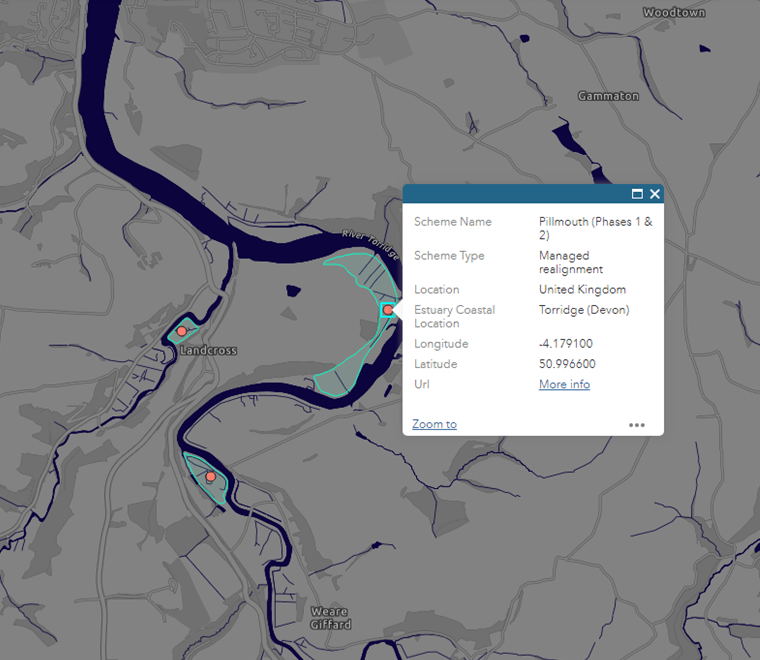
The latest update to our OMReg database provides valuable data on the location and extent of British managed and unmanaged realignments.
Read article