Published: Review of Natural Capital Assessment Approaches for UK Marine Policy
How does the application of the natural capital approach to marine and coastal environments inform management and policy work in the UK?
Read article

Discover the different types of seabed ecological survey, and which survey is the best fit for your project.
Seabed ecological surveys help identify and record the habitats and/or species in a given location, to help inform impact assessments, site management decisions and conservation policy development.
From drone and hovercraft surveys to grab sampling and DDV, there are many types of seabed survey. How can you know which survey is right for your project?

The diagram above provides an overview of the type(s) of seabed survey you will need, depending on the location of your project, and the type of data required. Follow the links below to discover more about each survey type:
Navigation

Drones, or Unmanned Aerial Vehicles (UAV) can provide aerial imagery of your survey site in a relatively short time. A drone can provide high-resolution georeferenced imagery and elevation data, and allow for high-level habitat mapping.
Pros
Can cover a larger area in a shorter space of time than hovercraft or on-foot surveys
Only one surveyor is needed
Cons
Drones require a licence to operate, and depending on location may be restricted by no-fly zones or need equipment unlocked by the manufacturer
If there is a need to purchase the drone, this can be a significant upfront cost
Poor weather conditions can limit drone flying and quality of data

Hovercraft can travel over water and mudflats to allow for both habitat mapping and core sampling in otherwise inaccessible intertidal areas.
Pros
Hovercraft allow access to the lower shore not accessible on foot
Hovercraft allow more in-depth biotope mapping than drone surveys
Cons
Operating costs can be high compared to other methods
Use of hovercraft can be restricted, e.g. in areas with wintering waterbirds

A survey hovercraft

A walkover, or on-foot habitat mapping, involves survey staff mapping biotopes on the shore with handheld GPS.
Pros
Walkover surveys provide detailed and precise biotope mapping and identification
Walkovers can also detail wider evidence at the site e.g., anthropogenic disturbance
Walkovers typically cause lower levels of disturbance to bird and mammal populations than hovercrafts
Cons
At least two surveyors are needed for each walkover
Walkovers have higher safety implications in tidal and mudflat areas than with a drone
Walkovers generally achieve lower area coverage over time (approximately 1 km / hour)

Core sampling allows the collection of sediment cores, both mud and sand for infaunal, particle size or chemical analysis in intertidal areas. Cores can be various sizes depending on requirements, though the typical standard size is 0.01 m².
Pros
Core samplers are lightweight, easy to use, and generally inexpensive
Cons
Core sampling can only happen at low water when intertidal sediment is exposed.
It can be difficult to collect a viable core in areas with compacted mud or high gravel content

Quadrat sampling allows for quantification of fauna in rocky shore habitats, used to estimate population abundance, density, frequency, and distribution.
Pros
Quadrat sampling provides a quantifiable estimation of fauna
Quadrats can be many sizes to meet survey requirements
Quadrats are generally lightweight, easy to use and inexpensive
Cons
Quadrats are not suitable for studying mobile fauna
Quadrats require highly accurate in-situ faunal identification by surveyors (unless samples are taken for later analysis)

A surveyor carrying out quadrat sampling

Van Veen grab samplers are used to obtain bottom samples from the seabed. They are generally used in intertidal areas or shallow subtidal in soft, muddy and/or sandy sediments.
Pros
A smaller grab than the Day and Hamon, Van Veen can be hand operated
Van Veen does not require a large vessel with A-frame or winch capacity
Van Veen can be operated in shallower areas
Cons
Van Veen is ineffective on seabed with high gravel or cobble content

Day grab is used to obtain bottom samples from the seabed. It is typically used in mud or sandy sediment, and is larger than a Van Veen, with a 0.1 m² standard grab size.
Pros
Day grab provides a quantifiable estimation of infauna (species living in sediment)
Cons
Day grab provides limited sampling of epifauna (species living on the seabed).
Day grab is ineffective on seabed with high gravel or cobble content

Hamon grab is used to obtain bottom samples from the seabed in coarser sand, gravel or cobble sediments. Grabs come in various sizes, though the typical mini-Hamon collects 0.1 m² samples. Hamon is regularly used for aggregate benthic monitoring, given the typical nature of the seabed in these areas.
Pros
Hamon provides a quantifiable estimation of infauna (species living in sediment)
Cons
Hamon provides limited sampling of epifauna (species living on the seabed)
Hamon is not suitable for sampling in fine or muddy sediments

Drop-down Video (DDV) can be used in all habitats, especially in rocky areas when grab sampling is not possible. The live top-feed allows for monitoring of the footage throughout the survey.
Large and small DDV systems are available depending on requirements and survey locations. For example, ABPmer’s bespoke DDV can simultaneously record video and high-resolution stills. Our smaller system has excellent functionality for surveying quay walls and vertical structures as it can be hand-held.
Pros
DDV has wide range of uses in terms of location and habitat type
DDV is non-destructive technique, ideal for sensitive habitats
Cons
DDV cannot sample infauna (species in sediment)
Video quality can be limited by underwater visibility
The evaluation of video material can be labour intensive

Sabellaria reef discovered through DDV

Scientific diving surveys are regularly used when detailed inspection is required, and remote sensing is not suitable.
Diving surveys can obtain data from all habitats, and are particularly useful in sensitive habitats such as subtidal reefs, which can be easily damaged by other techniques and cannot be physically sampled using a grab.
Pros
Diving can provide in-depth data collection and species identification
Cons
Diving can have a higher associated cost than other methods
Diving represents a greater risk to health and safety than remote sensing techniques
Prepared by Vicky West and Andrew Pearson, ABPmer marine ecology specialists
Main photo: Andrew Pearson
ABPmer’s ecological surveyors regularly coordinate and undertake pre and post-consent monitoring for coastal and marine developers. As an integrated consultancy and survey company, ABPmer offers a unique service to those operating in the marine environment.


How does the application of the natural capital approach to marine and coastal environments inform management and policy work in the UK?
Read article
What are the potential impacts of marine plastic on the MPA network of England and Wales? Read our report for Defra.
Read article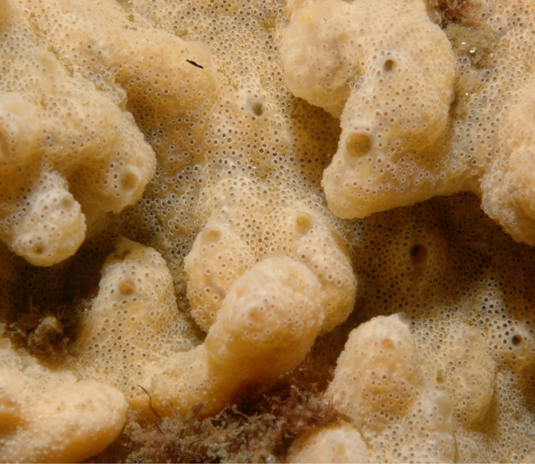
What are the links between climate change and marine invasive non-native species (INNS), and how can we manage the threat of INNS?
Read article