Ayre and Bowdun: consenting underway for 2 GW Scottish offshore wind farms
Discover how ABPmer's marine physical process assessments have helped enable consenting for the combined 2 GW Scottish wind farms
Learn more

Renewables | Consents and Licensing | Design Support
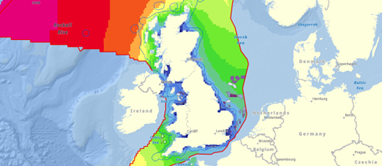
Updates to the UK Atlas of Marine Renewable Energy support understanding of sediment transport and seabed mobility in the North Sea and across the wider northwest European continental shelf
For over 20 years, the UK Atlas of Marine Renewable Energy has informed decision-making in UK marine renewable energy development. Originally published in 2004 under funding from the Department of Trade and Industry’s (DTI) Strategic Environmental Assessment (SEA) programme for Offshore Energy, today it is the most recognised source of publicly available data for waves, tides and winds in UK waters.
The Atlas is widely used for development planning through initial appraisal of metocean conditions, and its outputs frequently appear in baseline characterisation studies including sections of Environment Impact Assessment (EIA) reports.
In 2024, ABPmer made a number of major updates to the Atlas to reflect the evolving needs of the industry. In addition to usability improvements, a series of new layers were introduced, whilst the incorporation of wind and wave summary statistics and rose plots from ABPmer’s SEASTATES metocean database also extended the coverage of the Atlas outside of UK waters for the first time.
As part of our commitment to continual improvement of the Atlas, we have now added modelled sediment transport layers covering the North Sea and the northwest European continental shelf. These layers reveal spatial variation in the potential rate and direction of tidally driven sediment transport and are informed by hydrodynamic data from our state-of-the-art SEASTATES tide and surge model. Information on areas where sediment transport is restricted is also provided, reflecting areas where surficial sediment cover is thin or absent.
These new layers are the most detailed publicly available layers of this type for the region. They provide useful regional-scale understanding of the importance of tidally driven sediment transport processes.
Understanding the extent to which seabed sediment is mobile is an important consideration across a wide range of engineering and EIA related topics associated with the marine renewable industry sector. For instance, the net rate of sediment transport will influence the degree to which the seabed is mobile as well as the speed and direction of bedform migration. Larger sediment bedforms (such as sandwaves) which actively migrate across the seabed have the potential to expose or bury seabed assets such as electricity and telecommunications cables, affecting the risk profile for asset failure.
The rate of sediment transport will also influence the rate of seabed recovery following disturbance, including infilling of dredged channels and trenches. This may be an important consideration for nature conservation bodies as well as developers seeking to understand installation windows.
If you have any further suggestions for additional feature improvements or data, we would love to hear from you; please contact our team.
Explore the Atlas at renewables-atlas.info
ABPmer assists the marine renewables sector throughout the project lifecycle; from site selection and feasibility, through environmental impact assessment and consenting to engineering design, construction and operation and maintenance.
Ready to discuss your requirements? Get in touch.


Discover how ABPmer's marine physical process assessments have helped enable consenting for the combined 2 GW Scottish wind farms
Learn more
Scottish Government has appointed ABPmer to support the revision of its SMP for Offshore Wind Energy, and the production of the SMP for INTOG
Learn more
ABPmer is supporting key elements of the EIA for one of the world’s first large-scale commercial floating offshore wind farms. Learn more.
Learn more