Vessel navigation: how can swept path analysis inform safety and efficiency?
Understanding the space requirement for larger vessels is a key consideration for safe port access and optimal channel design
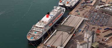
As ever larger ships use our ports and harbours, the tolerances (margins of safety) reduce and the challenge of vessel navigation increases. At the forefront of this industry is the Ultra Large Container Ship (ULCS), the giant of the sea, responsible for transporting a significant percentage of the world's goods across continents. These ships can reach lengths of over 400 metres, with widths of around 60 metres and draughts of 16 metres. Understanding the space requirement for these vessels whilst underway (moving) is a key consideration for access and channel design.
Swept path analysis: how it works
Key to improving navigational safety and operational efficiency around larger vessels is gaining a comprehensive understanding of their spatial requirements; this is achieved by swept path analysis.
Swept path analysis determines the area of sea or navigation channel (the path) that is covered (or swept) by a moving vessel. By recording the vessel’s transit using its Automatic Identification System (AIS) transmission, and accounting for the vessel’s dimensions and orientation, a footprint of sea area occupied by the vessel can be determined. Through the combination of these footprints over the course of a vessel’s transit, a swept path can be determined which allows analysis of manoeuvring characteristics, turning radius and sea area or navigation channel occupancy.
With multiple swept path transits, a composite analysis can be undertaken where the transits provide a density heat map (see image below). This analysis can be run for specific vessel type, draughts and/or time periods. The analysis provides a detailed visualisation of the area the vessel will occupy as it manoeuvres, which includes the routes taken during turns, berthing, and transits. This helps to recognise areas in which vessels specifically manoeuvre, allowing the user to consider areas with increased hazards such as locations which may be more susceptible to allisions (vessel strikes by other vessels) and groundings.
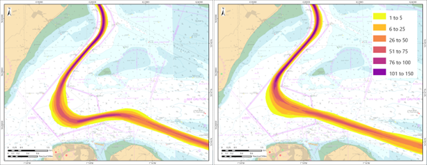
Vessel density of arriving (left) and departing (right) vessels in The Solent
The benefits of swept path analysis
By understanding the exact space requirements for different types of vessels, ports can optimise channel designs, berth layouts, and turning basins to accommodate larger or more frequent vessel traffic. This proactive planning can help to prevent marine incidents such as groundings, which can cause significant delays and port damage.
Additionally, the analysis can guide the placement of navigational aids, dredging schedules and the development of pilotage procedures, enhancing overall safety by ensuring that vessels have clear and safe routes through harbour areas.
The Southampton project
The Port of Southampton’s five-berth container terminal is the most productive in the UK. Heavily trafficked by Very Large and Ultra Large Container Ships, access through the deep-water channel is critical for the future operation of Southampton’s container trade.
Our navigation specialists worked with Associated British Ports - ABPmer’s sister company - to undertake a full swept path analysis to establish the spatial use of Category 6 and 7 container vessels, the world’s largest vessel type, navigating throughout the harbour’s jurisdiction. The objectives were to:
- Calculate the swept path for all vessels with a length overall (LOA) greater than 396 m
- Calculate swept path density, identifying locations in the study area with greatest concentration
- Compare inbound and outbound vessel swept path
The analysis provided insights into the channel’s capacity to accommodate deep-draught vessels and allowing the identification of areas that may require future dredging, or areas that could be dredged to a different or lesser depth.
Understanding the spatial footprint of vessels as they transit through port approaches and harbour channels is critical for informed and strategic decision-making in port operations. Swept path analysis provides a detailed visualisation of the navigable area utilised by various vessel types during manoeuvring, berthing, and transits. This knowledge not only informs future port operations and marine safety requirements by identifying high-density and constraint-prone areas but also supports the optimisation of port layout and maintenance. By integrating this data into operational planning, port authorities can ensure that navigation remains safe and efficient, particularly for deep-draught and ultra-large vessels.
Building on swept path analysis: enhanced risk management and efficiency
Swept path analysis like that provided to ABP Southampton offers significant potential for further analyses to enhance understanding of vessel behaviour, optimise port operations and inform future planning. By leveraging detailed AIS data and accompanying metadata, the following analyses can be undertaken:
Comparative analysis under specific environmental conditions
Analysing vessel transits in relation to historical environmental conditions can offer valuable perspectives on how external factors influence navigation. Specific focus areas include:
- Weather impacts: Evaluating vessel tracks during adverse weather conditions (such as high winds or reduced visibility) to identify operational challenges and propose mitigation strategies
- Tidal influences: Comparing vessel tracks during varying tidal flow states, such as spring ebb tide versus a neap ebb tide, to assess how water flows and even water levels affect manoeuvrability and routeing decisions
This analysis can support in enhanced planning and risk management giving further insight into vessel behaviour under similar conditions.
Inbound v outbound traffic comparisons
Creating comparative plots of inbound and outbound vessel tracks can help identify differences in navigational strategies, spatial requirements and potential congestion points. This analysis could highlight:
- Variations in swept path dimensions for arriving and departing vessels
- Differences in transit times, speed, and heading adjustments based on the direction of travel
- Impacts of environmental factors such as tidal flow and prevailing winds on inbound versus outbound movements
Insights from this analysis can support better scheduling and routeing to optimise traffic flow within the port area.
Tug usage analysis
Understanding the interaction between vessels and tugs is crucial for enhancing port operations, particularly for large or heavily loaded vessels. Key areas of focus include:
- Tug manoeuvrability areas: Analysing the spatial footprint of tugs assisting vessels, often referred to as the ‘tug shelf’, can reveal the extent of navigable space required for safe operations. This could inform berth designs and tug deployment strategies
- Tug usage patterns: Evaluating how tugs are used around vessels, including the number of tugs deployed and their positioning, could help improve tug operations and ensure sufficient availability during peak periods
Speed gate analysis
Speed gate analysis evaluates vessel speeds at key locations to assess compliance with navigational safety measures and operational efficiency. The analysis includes:
Speed compliance and safety
- Monitoring vessel speeds at designated checkpoints to ensure compliance with speed limits
- Identifying high-risk areas where excessive speed may lead to safety concerns, such as near berths or turning basins
- Providing data to support enforcement measures and speed advisories
Speed variations and traffic flow
- Analysing speed variations based on vessel type, draught, and environmental conditions
- Identifying trends in acceleration or deceleration patterns near critical zones
- Using findings to optimise traffic flow and reduce unnecessary fuel consumption
Dredge depth awareness
Dredge depth awareness ensures channels are maintained at appropriate depths to accommodate deep-draught vessels safely. This involves:
Identifying critical areas
- Analysing vessel draught data against recorded depths to identify areas at risk of insufficient clearance
- Mapping high-density swept path regions that may require additional dredging
- Assessing whether deeper dredging in specific areas could reduce vessel manoeuvring constraints
Optimising dredging efforts
- Using historical vessel movements to predict future dredging needs
- Reducing unnecessary dredging efforts to lower costs and environmental impacts
- Ensuring key navigation areas remain safe and accessible for larger vessels
Vessel scour analysis
Vessel scour occurs when propeller wash and vessel movement disturb the seabed, potentially leading to sediment displacement and structural concerns. Analysing vessel scour involves:
Identifying high-risk areas
- Mapping areas with high vessel density and frequent propeller activity
- Identifying locations where scour is impacting berths, quay walls, or natural habitats
- Analysing the influence of vessel speed and thruster use on sediment displacement
Mitigation strategies
- Exploring design modifications for breakwaters or seabed reinforcement
- Adjusting vessel approach angles or limiting thruster use in sensitive areas
Summary
Swept path analysis is a useful tool to examine the use of vessel movements, which is crucial considering the ever-increasing number of large and complex vessels entering our ports. By quantifying the spatial footprint of vessel movements from AIS data and combining with hydrographic or environmental information, port authorities gain a robust evidence base for making informed decisions on channel design, berth configuration, tug deployment, and navigational safety procedures.
As demonstrated through the Southampton case study, this analytical approach provides site specific benefits; highlighting areas of high traffic density and utilised areas which can inform dredging priorities and identifying operational constraints which could have been overlooked. Furthermore, enhancements such as inbound/outbound comparisons, tug usage assessments, and speed gate monitoring advance swept path analysis from a spatial planning tool to a basis of holistic risk management and operational optimisation.
Where heightened regulatory scrutiny, environmental sensitivity, and economic competition, the ability to anticipate navigational challenges and design resilient marine infrastructure has never been more critical. Through the application of swept path analysis, ports can ensure they remain safe, adaptive, and fit for purpose both now and into the future.
ABPmer is a specialist provider of risk management services to ports, harbours and marinas. Our experienced maritime specialists offers port development assessments, Designated Person (PMSC) services, mooring plan support and port asset management, as well as tailored training courses on marine safety and PMSC compliance.
Ready to discuss your requirements? Get in touch.
Marine accident and incident investigation: best practice
How can Harbour Authorities, and owners of marine facilities, learn from marine accidents or incidents to help prevent reoccurrence?
Read article
Lymington Harbour completes first audit under new Ports & Marine Facilities Safety Code
Our recent port marine safety audit for Lymington Harbour makes them among the first Organisations audited under the new Code
Read article
Ports & Marine Facilities Safety Code 2025: what has changed?
The UK’s national standard for safe port marine operations, previously known as the Port Marine Safety Code, has had its first major update since 2016
Read article